In this blog article I am going to summarize the studies about the fish
fauna in the Gambia River after 2000. First comes the joint survey
between french scientists from IRD (Institut de recherche pour le
développement), IFREMER (Institut français de recherche pour
l'exploitation de la mer), and Department of Fisheries, the Gambia from
November 2000 to April 2002. The survey is composed of two parts:
hydro-acoustic and seining, which are summarized in Albaret et al. (2004), Guillard et al. (2004), Simier et al. (2006) and Guillard et al. (2012), respectively. In addition, I will also briefly introduce the survey done by the IRD team in Dakar, Senegal in the lower estuary in a similar period (2002). Their results were summarized in Vidy et al. (2004).
在這一篇文章中,我會對在2000年後,針對甘比亞河魚類的調查研究做個整理。首先是法國研究團隊(IRD, IFREMER)以及甘比亞漁業署,在2000年11月至2002年四月於甘比亞河下游區域所完成的一項共同調查研究。這研究分成聲納調查以及圍網採樣兩部分,結果分別發表在Albaret et al. (2004)、Guillard et al. (2004) 、Simier et al. (2006) 及Guillard et al. (2012)這四篇文章中。另外大約在另外一個在塞內加爾IRD的法國團隊,也針對甘比亞河下游做了一次調查,其結果總結在 Vidy et al. (2004)這篇報告。因為調查時間地點接近,就也順便介紹。
Four papers about the join survey by IRD, IFREMER, and the Department of Fisheries of the Gambia:
 |
| Albaret et al. (2004). |
 |
| Guillard et al. (2004) |
 |
| Simier et al. (2006) |
 |
| Guillard et al. (2012) |
First let us make a quick review of area covered in their survey and its environmental settings. According to Albaret et al. (2004), the survey examined 44 stations from the river mouth, going upstream until to Deer Island (Figure 1). The surveyed area is shallow, with depths ranging from 2 to 12 m (Figure 2). As summarized in previous studies, the Gambia River has a "normal estuary" with decreasing salinity with increasing distances to the river mouth. Also the saline front moved up- and downstream as the season changed between rain and dry season (Figure 3).
首先我們先針對調查所研究的區域,還有其環境因子作個簡單整理: Albaret 等人的研究,總共在44個站點採樣,涵蓋區域從河口一直到靠近中游區的鹿島(Deer Island, 圖一)。 採樣區域不深,深度在2 ~ 12m
之間(圖二)。就如同先前研究所指出,甘比亞河是"正常型河口",鹽度隨著離河口距離增加而降低
。同時淡海水分界線,也隨著雨季乾季的交替而在往上游或往出海口移動 (圖三)。
 |
圖一. 2000年 IRD-Gambia聯合調查中44個採樣點的分布圖。
Figure 1. Location map of the 44 sampling stations of 2000 joint survey. Credit: Albaret et al. (2004) |
 |
圖二. 甘比亞下游自河口至中游區末端的深度變化 Credit: Darboe (2002)
Figure. 2. Depth profile of surveyed area from river mouth toward upstream. |
 |
圖三. 環境因子從河口至上游的變化圖。
Figure 3. Environment parameters from river mouth toward upstream |
Their survey consist two parts: acoustic and purse-seine survey. We are going to first introduce the acoustic survey done by Guillard et al. (2004) using the ecosounder (SIMRAD EY500, split-beam, 120 kHz frequency). The acoustic survey is conducted during daytime and two protocols are applied: (1) classical mobile acoustic survey and (2) stationary (moored) sampling (Figure 4). The former means that the echosounder was attached to a boat which was cruising along a zip-zap transect with a speed of around 6 km per hour and broadcasted the sound waves vertically toward the bottom. The second means the boat kept still and the echosounder broadcasted the sound waves. The survey lasted around 30 minuntes for both approaches. The scientists also measured the hydrological parameters when they were conducting the survey.
For the acoustic survey in the Gambia River, two types of fish echoes were encountered, individual targets and schools (Figure 5). The echos of schools occurred mostly in the surface and only occurred in the lower estuary. The mobile and stationary protocol have very similar results in terms of target echo strength with high correlation. Also they observed large seasonal and spatial variation in fish biomass estimate in the sampled area, as indicated by back-scattering coefficient (see this manual for detailed information about scattering coefficient). The fish biomass showed clear contract between winter and summer or dry and rain season that it was high in the lower estuary in winter (Nov-Dec) and higher in the upper estuary in spring and summer (April to June, Figure 6).
他們團隊針對甘比亞河口區域的研究調查分為兩大部分:聲納調查以及圍網調查。首先我們介紹由Guillard et al. (2004) 所做的聲納調查研究,所使用聲納型號為: SIMRAD EY500, 屬於分區聲納(Split beam)、聲波頻率120 千赫茲。他們的聲納調查在白天進行,又分為兩種方式: 動態巡弋以定點調查。動態巡弋指漿聲納裝至在調查船上,在設定好的穿越線上以時速約六公里的速度巡弋,同時聲納往河底發送訊號,並接受河中生物的所反射的回聲訊號。定點調查指船在設定好的調查點固定不同,同時向底部發送聲納訊號並接收回聲。兩種方式(動態巡弋及定點調查)大約都耗時三十分鐘,並且同時量測必須的水文參數資訊。
參照圖五,他們發現有兩種聲納回聲訊號: 個體訊號及(魚)群體訊號,同時魚群回聲主要在表層,並且只有在河口下游出現。定點及動態巡弋所得的目標個體回聲強度之結果類似,並兩者有高度相關。將回聲強度當做魚類豐度指標(細節可參照FAO操作手冊),可以得知甘比亞河口調查區域的魚類豐度有高度的時空變化(圖六): 在冬天(或乾季初期),在河口下游魚類豐度較高,另外在春夏(乾季晚期),則是河口上游有較高的魚類豐度。
 |
圖四. Guillard 等人的聲納調查點分佈圖。Credit: Guillard et al.(2004)
Figure 4. Distribution of transect and stations for the acoustic survey |
 |
圖五.聲納顯示出(a)個體(b)(魚)群體回聲訊號。Credit: Guillard et al.(2004)
Figure 5. Echos for (a) individual and (b) (fish) schools. |
 |
圖六.利用聲納估計生物量的時空分佈。Credit: Guillard et al.(2004)
Figure 6. Spatial distribution of biomass estimate from different surveys in different time |
A purse-seine survey was conducted simultaneously with the acoustic survey on the second boat. The purse-seine survey has been applied for fish communities in other West African rivers. The purse-seine is 250 m long, 20 m deep with a mesh size of 14 mm. Nine trained fishermen deploy the net without any surface search and the results were summarized in Albaret et al. 2004.
They classified the fish species of the Gambia Estuary into the 8 bio-ecological categories. Five categories with affinity to estuary from high to low are: strictly estuarine species (Es), estuarine species from marine origin (Em), the marine-estuarine species (ME), the marine species accessory in estuaries (Ma) and the marine species occasional in estuaries (Mo). The other three categories represented different affinity to freshwater: estuarine species from continental origin (Ec), the continental species with estuarine affinities (Ce), and the continental species, occasional in estuaries (Co). The fish in the Gambia River estuary were composed of mostly Em and ME species, suggesting the influence of marine environment. Moreover, the Em species dominated the fish community in terms of individuals and biomass, which was contributed mainly by Pseudotolithus elongatus, Ethmalosa fimbriata, and Ilisha africana (Figure 7).
The sciaenid Pseudotolithus elongatus was the most common fish species in the fish community with a remarkably wide spatio-temporal distribution in the estuary (> 96 % occurrence). It occurred in large number for all season at all sites, from sea water to totally fresh water (Figure 8). Even during the end of the rain season with maximum flood (September), it was abundant in the upper reaches of the estuary. In addition,P. elongatus was possibly able to breed in the Gambia estuary because all stages of the life cycle were represented in the system (All stages of P. elongatus were also found in Vidy et al. [2004]).
The clupdeids Ethmalosa fimbriata, Ilisha africana and Sardinella maderensis was the second most important fish species in terms of total fish numbers, biomass and occurrence. Both juveniles and adults were recorded in seine net samples throughout the estuary. However, they showed a clear seasonal-related spatial pattern: They stayed all year round in the lower reaches and their abundances generally decreased as the distance to the sea increased. They also tend to move upstream during the dry season (Figure 8).
Synodontis gambiensis is a species of continental origin with a strong estuarine affinity. It was more abundant in the upstream sites than in the lower reach stations, but this spatial distribution trend was also influenced by different season. As the dry season progressed, it had started moving back upstream and was confined to the upper reaches during the dry season (Figure 8).
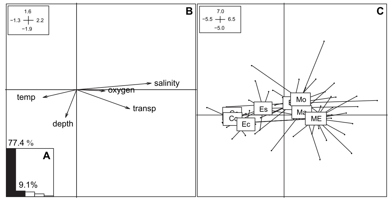
Simier et al. (2006) analyzed the physical environment variables and the fish community based on these eight bio-ecological categories using a combination of factor analysis, principal analysis and multi-table comparison. The physical environment was characterized by a longitudinal gradient (from high to low) of salinity, dissolved oxygen and transparency that explained a majority (77.4 %) of total variance. Different bio-ecological categories of the fish also associated with this east-west environmental gradient, contrasting marine and freshwater affinity assemblages (Figure 9). This longitudinal gradient also exhibited seasonal variations, that it was the most complete in December (early dry season) and was the weakest in June (at the end of the dry season).
Then Guillard et
al. (2012) showed that two simultaneous sampling, acoustic and
purse-seine, produced similar spatial trends in the abundance indexes of fish
(Figure 10) and two indexes were highly correlated (Figure 11). They also examined possible interferences from other
covariates with regression tree, but i think the correlation between two abundance indexes is a bit blurry. It might be clearer if the confounding effects from other covariates can be removed
using statistical modelling, like generalized linear model framework.
另外一艘船上,別組團隊在聲納調查的同時進行圍網調查。圍網調查與此團隊之前在西非其他地區採用同樣的漁法: 使用長250公尺、深20公尺,網目14公厘。網具由九位經過訓練的漁民操作,並且採取"盲目取樣",不針對魚群下網。數次調查總共採取到30科70種魚類(表一),石首魚類(Pseudotolithus elongatus)是最常出現、數量最多的種類。其次是三種屬於鯡科的 Ethmalosa fimbriata、 Ilisha africana 及 Sardinella maderensis。另外此次研究並沒有採集到數種在西非河口地區常見的魚種。如兩種鑽嘴魚類 (Gerres nigri 及 Eucinostomus melanopterus)是廣泛在西非分布的常見種,但此次採樣僅採集到幾隻個體。同時也只採集到五種鯔科魚類,同時三種常見種(杜氏鮻 Liza dumerili、烏魚 Mugil cephalus 及Mugil bananensis)採集數也僅有數隻。也沒有採集到庫里鯔 (Mugil curema)。
作者同時將這些河口魚種,依照對於河口及淡水的依賴度分為八大群。以對河口的依賴度由高至低分為嚴格河口群(Es)、河口海洋起源群 (Em)、海洋河口群(ME)、海洋可進入河口群(Ma)以及海洋群偶爾利用河口群(Mo)。從對淡水依賴的程度由高至低分為: 河口淡水起源群(Ec)、淡水親河口群(Ce)以及淡水偶爾利用河口群(Co)。甘比亞河河口主要以河口海洋起源群 (Em)及海洋河口群(ME)類為主,其中又以石首魚及鯡科為主(圖七)。
石首魚(Pseudotolithus elongatus)是此次調查最常見的種類,出現率超過96%,且每個季節都可以從最靠近出海口直到最靠近甘比亞河中游的站點,發現到大量的個體(圖八)。另外此魚即使在雨季的末期,河水水流量最高的九月,仍然可以在最上游的站點中採集到。另外,由於採集到各個發育階段的個體(從稚魚至成魚[Vidy et al. 2004]),因此作者推測此種魚可能可以在甘比亞下游繁殖。
鯡科魚類(Ethmalosa fimbriata, Ilisha africana 及 Sardinella maderensi) 是在豐度、生物量以及出現頻度第二重要的種類,同時同樣可以發現稚魚和成魚。但和石首魚不同的是,鯡科魚類有明顯的區域分布趨勢: 大多分布在靠近海洋的下游河口地區,豐度隨著離海距離增加而降低。然而隨著乾季的尾聲,鹽度往上游推進時也會到河口上游分布。甘比亞倒游鯰(Synodontis gambiensis)是一種淡水魚類,但是喜歡至河口地區生活。其豐度隨著離海距離增加而增加,但是在雨季晚期、水量增加時會往下游地區移動,但在乾季時,分布就主要侷限在上游地區(圖八)。
Simier et
al. (2006) 將調查區域之魚類按照先前的方式分為八個生態群,然後利用多變量統計方法中的因素分析、主成分分析以及多表格比較法分析物理環境魚類聚落。甘比亞河下游物理環境可以以東西向的鹽度、溶氧及透明度梯度所解釋(這些變數可以解釋全體變異的77.4%)。而不同的魚類生態群分布在不同的物理梯度的位置,代表這些生態群對於海水或淡水不同的喜好依賴程度(圖九)。然而這樣東西向的梯度同時受到季節的影響,在乾季初期(12月)最為明顯,而在乾季尾期雨季初期(6月)此梯度出現最小的對比。
最後這一魚多吃的調查,竟可在2012又發表了一篇文章(Guillard et
al. 2012),比較魚類豐度指標是否會因為不同採樣方式(圍網或聲納)而有所差異 。兩個採樣方式所得之豐度指標,大體呈現出類似的趨勢(圖十) ,同時不同方式所求得之豐度指標有高度相關(圖十一)。雖然作者用詭異的迴歸樹來嘗試將其他干擾因素排除,但我覺得簡單用泛線性模式家族等統計方法,就可以將這些干擾因素排除,相關不是很好看的圖十一應該也可以變得有說服力些。(基本上我覺得這一篇會被接受也很神奇....可見SCI論文不難寫呀....)
 |
表一.利用圍網調查所得之魚種、生活區域、出現次數、數量及生物量。Credit: Albaret et al. 2004.
Table.1. Summary table for the purse-seine survey. |
 | |
| 圖七.八種棲地群的種類豐度、個體數量及生物量。Credit: Albaret et al. 2004. Figure 7. Species richness, numbers and biomass for the fish from the 8 biological categories. |
 |
| 圖八.一些重要魚種之豐度與離海距離之變化。Credit: Albaret et al. 2004. Figure 8. The spatial trend of the abundance of some essential fish species. |
 |
圖九. 圍網及聲納之魚類豐度指標比較圖。Credit: Guillard et al.(2012)
Figure 9. Fish abund |
 |
圖十. 圍網及聲納之魚類豐度指標比較圖。Credit: Guillard et al.(2012)
Figure 10. Fish abundance indexes from purse-seine (left panels) and acoustic survey (right panel)
|
 |
圖十一. 圍網及聲納之魚類豐度指標相關圖。Credit: Guillard et al.(2012)
Figure 11. Correlation between abundance index from purse-seine and acoustic survey |
Now lets move to another study in the same region and period, Vidy et al. (2004). Their object is to examine the juvenile fish assemblage occupying the lateral mangrove channels of the estuary of Gambia River. In May, September and November, 2002, the team collected fish juveniles by small meshed fyke-nets in six stations from the river mouth to the 130 km upstream (Figure 12). The nets were set at night in channels adjacent to the main channel of the estuary. The sampling was conducted to coincide with the new moon phase and an evening flood tide as close as possible, given the assumption that that juvenile fish enter the mangrove area with the tide.
The catch are dominant by small-sized individuals (< 100 mm fork length), as reflected in the small mean size of most species (Table 2). The juvenile fish assemblage of the Gambia estuary was dominated by the estuary-residing species, while the juveniles of fish species with high affinity to seawater are limited in numbers.Variations in juvenile abundance were also linked to recruitment seasons and the period from May to September-November suggests a breeding season similar to that of
the resident estuary species, as indicated by the join of early juveniles in September to November, for example, Pseudotolithus elongatus. Generally for the species spawning at sea, their juvenile abundance decreased with increasing distance from the sea, with an exception of Polydactylus quadrifilis that its juveniles were found in the upper stations with very low salinity.
接下來,是一篇大約在同時期,採樣區域也重疊的達卡法國研究團隊,針對甘比亞河下游所做的研究,結果整合在Vidy et al.
(2004)這篇文章。他們於2002年五月、九月還有十一月,在與甘比亞河主流相接的主要水道設小網目的袋張網採樣,從河口到上游130公里處總共設立
六個採樣點(圖十二)。因為她們假設小體型的稚魚會利用潮汐進入甘比亞河口,因此研究者盡可能在新月的大潮採樣。
樣本以小型個體的稚魚為主,同時大多尾叉長小於100 mm(表二)。魚種多為生活在河口的種類,海洋性魚種數量有限。 稚魚數量的變化也反映了入添的季節,由於稚魚在九至十一月的數量達到高峰,因此可以推測這些魚種在五月至九月產卵,而以石首魚( Pseudotolithus elongatus)為代表。在海洋產卵的魚種,一般稚魚數量隨著離海距離增加而減少,但是馬拔魚(Polydactylus quadrifilis) 是一個例外。研究者在最上游、低鹽度的站點,仍然可以採集到馬拔魚的稚魚。
 |
| Vidy et al. (2004) |
 |
圖十二. Vidy 等人在甘比亞河下游的採樣點。Credit: Vidy et al.(2004)
Figure 12. Sampling stations in Vidy et al. (2004) |
 |
表二. 採集到之物種個數及體型。Credit: Vidy et al.(2004)
Table 2. The number and size of the collected fish species |
Then Louca et al. (2009) further examined the fish fauna in the floodplains in the lower reach of the Gambia. The floodplain borders the main channel of Gambia River and the last 200 km was fringed by mangrove forest. The sample sites locate in the North Bank Region east of Farafenni town and are approximately 193 and 209 km upstream, close to the saline water limit in the end of the dry season (Figure 13). Fish were monthly sampled using cast and hand nets along two transects on the floodplain, and with fyke-nets in two creeks from May to November 2005 and 2006.
Totally 32 fish species belonging to 15 families were collected from the floodplain transects in 2005
and 2006 (Table 3). Greater fish species richness was associated with low conductivity, low pH and deep water. The species richness was greater in creeks than that in floodplain habitats, probably because they acted as conduits for fish passing in and out of the floodplain. The also found that floodplains of the lower reach of the Gambia River is an essential fish habitat as both a habitat for small-sized fish to complete their life history, as well as a nursery habitat for some fish species mainly encountered in the main channel, as indicated by high percentage of immature juveniles.
總共採集到32種15科的魚類(表三)。低電導度、低PH值以及深水區和高魚類種類數有關,同時在支流有比較多的魚種類數,這可能是因為支流是魚類進入及離開泛洪區的中間通道之緣故。同時他們也發現研究的甘比亞河泛洪區是重要的魚類棲地,讓小型魚類會可以在泛洪區完成完整的生命週期。並且由於在泛洪區發現常在主流發現魚種的稚魚,代表泛洪區同時也會這些魚種作孵育場之用。
 |
| Louca et al. (2009). |
 |
圖十三. Louca 等人採樣點地圖。河旁的灰色區域為泛洪區域。Credit: Louca et al.(2009)
Figure 13. Sampling sites (BKD and P) in Louca et al. (2009). The grey area indicates the floodplain |
 |
表三. 魚種之相對頻度。Credit: Louca et al.(2009)
Table 3. Relative abundance of fish species in Louca et al. (2009). |
As far as I know, few studies have examined the fish fauna in the freshwater habitats (salinity zero) of the Gambia River that the Czech team, who has done a couple of surveys in and near the Niokolo Koba National Park in Senegal, provide the best insights of the fish fauna in the freshwater region of Gambia River.
Totally 429 individual fishes belonging to 14 species and six families were recorded (Table 4). The most abundant species was Rhabdalestes septentrionalis and R. senegalensis and Hemichromis bimaculatus are the species with the highest appearance (> 30 %). By direct observation, they were able to reveal the species-specific fish-habitat association. For example, for two species with similar size ( ~ 30 mm standard length), Aplocheilichthys normani inhabited shallow marginal areas with no flow and it occurred near the water surface, while Nannocharax ansorgii, preferred deeper region farther from the shore.
就我所知,對於甘比亞河中上游淡水區域魚類種類的文獻不多。而捷克團隊在甘比亞河上游,塞內加爾境內的Niokolo Koba國家公園所作的研究,提供了甘比亞河淡水區域魚類相重要的資訊
首先是他們的一次潛水調查,也是目前針對甘比亞河魚類相唯一的直接在環境觀察的研究。他們在2007年三月中旬,在甘比亞河中游,Niokolo Koba國家公園中Badoye
地區的一個深水淡水池進行研究。研究者潛水觀察魚類存在與否,如果看到魚類,進可能記錄相關生物資訊,例如數量、魚類體型(標準體長),發育階段(稚魚、
亞成魚或成魚)以及在水中之深度位置。同時也記錄相關的環境水文參數。
他們總共觀察到429隻魚類個體,屬於14種六科(表四)。數量上來說,成群出現的燈魚類Rhabdalestes septentrionalis 數量最多。然而已出現頻度來說,則以塞內加爾燈魚 R. senegalensis 及寶石慈鯛最為常見,出現機率超過30%。因為是潛水員直接在水下觀測,因此他們的研究可以直接反映不同魚種對於環境的不同喜好。例如兩種同樣是約30mm的小型魚,鱂魚Aplocheilichthys normani 喜歡在離岸無水流的表層棲息,而這種Nannocharax ansorgii鯉科魚澤喜好棲息在離岸較遠的水深處。
 |
| Reichard (2008) |
 |
表四. 在Niokolo Koba 國家公園紀錄之魚種體型及數量。Credit: Reichard (2008)
Table 4. Size and numbers of fish species found in Reichard (2008). |
Then it comes their second study, White et al. (2012), which was undertaken also in Niokolo Koba National Park in Senegal. In this 4-year survey (2003-2007, likely) they collected the fish using the seine net and at each site, a single sample consisted of usually three seine hauls (possibly from non-overlapping area swept). Sampling sites were classified into five categories, according to decreasing connectivity to the main channel: (1) main river channels, (2) tributaries, (3) oxbow lakes, (4) temporary water bodies, and (5) spring area (only during dry season).
They collected totally 49 fish species (Table 5). The habitat use of the fish varied widely among species and seasons. For example, some fish such as Barbus macrops, Barbus pobeguini, and Rhabdalestes septentrionalis
occurred generally among all habitats and seasons, whereas other species were observed in certain habitats and/or seasons: Brienomyrus brachyistius occurred only in spring pools, and Ctenopoma petherici
was found only in temporary floodplain pools during the wet season (rain season) and in the tributaries and oxbow lakes during the dry season.
According to non-metric multidimensional scaling (Figure 15), the fish assemblage depended on both habitats and seasons. During the rain season, the fish assemblage in the main river channel was similar to that in the tributaries, while the oxbow lakes and temporary water bodies had distinct
assemblages (Figure 15). In the dry season, however, the fish species composition in the tributaries and oxbow lakes altered greatly with high variation along y-axis and x-axis in Figure 15, respectively, which implied joining of different fish species. Also in the dry season,
the fish assemblage in the spring pools was distinctly different to main river channel and connecting tributaries.
捷克團隊接下來繼續在Niokolo Koba國家公園進行研究,他們更利用並發表White et al. (2012)這篇文章。在這為期四年的研究中,研究者利用圍網採集魚類,並且在每一個宰樣點,一個樣本通常下網三次(三次捕撈之涵蓋範圍應該不同)。而研 究者根據和主河道的連接程度,將採樣點分成五類: (1)主河道、(2)支流域、(3)牛軛湖、(4)暫時性水體及(5)只有在乾季出現的湧泉區。
他們在這四年研究中採集到49種魚種(表五),而且也發現魚類棲地的利用,有很大的種間及季節的變異。例如Barbus macrops, Barbus pobeguini, 及 Rhabdalestes septentrionalis 這三種類對棲地選擇性不高,廣泛在每個季節的所有棲地出現。然而有些魚種只會在某些棲地或季節出現,如Brienomyrus brachyistius 只有出現在湧泉區,而 Ctenopoma petherici在雨季出現在支流,而在乾季則分布在牛軛湖。
研究者利用非計量多向度法,分析不同樣本魚類種類組成的差異(圖十五),結果發現魚類種類組成也受到季節和棲地的影響。在雨季時,甘比亞河河川主流和支流魚類相很接近,然而和牛軛湖及暫時性水體魚類種類組成就差異很大。然而在乾季時,支流和牛軛湖的魚種種類分別在Y軸及X軸出現劇烈的震盪,暗示有不同的魚類種類加入群體。在乾季的湧泉區,也和主流及相連接的支流,有著明顯不同的魚類種類組成。
捷克團隊接下來繼續在Niokolo Koba國家公園進行研究,他們更利用並發表White et al. (2012)這篇文章。在這為期四年的研究中,研究者利用圍網採集魚類,並且在每一個宰樣點,一個樣本通常下網三次(三次捕撈之涵蓋範圍應該不同)。而研 究者根據和主河道的連接程度,將採樣點分成五類: (1)主河道、(2)支流域、(3)牛軛湖、(4)暫時性水體及(5)只有在乾季出現的湧泉區。
他們在這四年研究中採集到49種魚種(表五),而且也發現魚類棲地的利用,有很大的種間及季節的變異。例如Barbus macrops, Barbus pobeguini, 及 Rhabdalestes septentrionalis 這三種類對棲地選擇性不高,廣泛在每個季節的所有棲地出現。然而有些魚種只會在某些棲地或季節出現,如Brienomyrus brachyistius 只有出現在湧泉區,而 Ctenopoma petherici在雨季出現在支流,而在乾季則分布在牛軛湖。
研究者利用非計量多向度法,分析不同樣本魚類種類組成的差異(圖十五),結果發現魚類種類組成也受到季節和棲地的影響。在雨季時,甘比亞河河川主流和支流魚類相很接近,然而和牛軛湖及暫時性水體魚類種類組成就差異很大。然而在乾季時,支流和牛軛湖的魚種種類分別在Y軸及X軸出現劇烈的震盪,暗示有不同的魚類種類加入群體。在乾季的湧泉區,也和主流及相連接的支流,有著明顯不同的魚類種類組成。
 |
| White et al. (2012) |
 |
圖十四. Niokolo Koba 國家公園內之採樣點分布地圖。Credit: White et al. (2012)
Figure 14.Sampling sites in Niokolo Koba National Park |
 |
表五. 在Niokolo Koba 國家公園紀錄之魚種豐度。Credit: White et al (2012)
Table 5. Fish abundance index (CPUE) in White et al. (2012) |
 |
圖十五. 各樣本魚類種類相成之非計量多向度圖。當樣本點越靠近,表示其魚種類組成越相近。Credit: White et al (2012)
Figure 15. Non-metric multidimensional scaling plot for the samples. Axes are composed of fish species loadings. Close points suggested similar fish species composition. |
In conclusion, although locating in the tropics, and generally being considered as homogenous habitats, the Gambia River is in fact heterogeneous in terms of essential physical parameters, for example, salinity and water flow with strong among habitats and between dry-rain seasonal contrasts. Therefore, the fishes in the Gambia River showed large spatial and temporal variation in the species composition, occurrences, abundances, and life-history stages. The Gambia River is by far (2015, end of August) not interrupted by any artificial dam, and therefore it provides an ideal place to study the relationship between fish, marine and freshwater environment in a nearly pristine (or relatively less development pressure) state in terms of connectivity from the river mouth to the upper reaches. However, in most of the studies the research efforts were deposited in the saline part of the lower reach region (corresponding to the West Region and Lower River Region in the Gambia), possibly because of (1) highly productive environment, (2) importance in fisheries as fishing or nursery grounds, and (3) fewer logistic issues. One of the few studies on the freshwater part of the Gambia river located in the Niokolo Koba National Part in Senegal, leaving a vacuum about the fishes in the region starting from the Central River Region and Upper River Region of the Gambia. Studies on these section will have good contribution on the general understanding of the fish in this last few un-distributed large river in the world.
最後總結這篇長文:
雖然熱帶地區過去往往被認為是穩定、缺乏環境條件變異的地區,但是熱帶地區的甘比亞河絕對不符合這陳舊的假設,是個環境因子有著劇烈變化,帶有鮮明棲地間及乾濕季對比的區域。在此環境生活的魚類,其種類組成、出現頻率、族群大小及生活史階段在時空上有相對應的變異。甘比亞河現今(2015年八月底)仍然沒有人為的物體(如水壩)攔阻,因此甘比亞河是一個研究魚類如何在"自然"、"無干擾"、"無障礙"的環境下,與海水及淡水環境互動之理想區域。然而甘比亞河中下游有鹽度之區域可能因為(1)高生產力、(2)作為漁場或孵育場,對於甘比亞漁業有高重要性,及(3)較容易抵達採樣等原因,目前大多數的魚類研究都集中在下游區段。對於甘比亞河淡水區段的研究,所知也僅有捷克團隊在塞內加爾境內的Niokolo Koba國家公園的系列研究,而針對甘比亞河在甘比亞中游省至上游省的區段的研究目前人付之闕如。因此對於分布在這區段的魚類研究,將可在這條少數未被人類阻斷的大河,其魚類分布模式提供更完善的資訊。